road to Shalimar, 1952

From ‘The road to Shalimar’ by Carveth Wells, 1952.

H.M.S. Pinafore.
This one too is still around 
Sher Garhi palace. Built by Afghan governor Ameer Jawan Sher Qizilbash.
Later became palace of Dogras. 

Destroyed in fire, I believe, in late 1970s.

-0-

Lost in Space

Moving east, high over the “roof of the world” – the Himalayas – Conrad remembers saying to himself,

“Why must men fight each other instead of enjoying the bounty and beauty of the world?” these are the
snow capped peaks – including K2 (28, 250 feet), world’s second highest mountain – in the extreme
north section of Indian Kashmir on the ill-defined India-China border. China invaded India in 1962
in a dispute over border claims in the area; now India and Pakistan are fighting 150 miles to the south.

Kashmir from Space.
Life. 24 Sept, 1965.

One might look at this and wonder: which one is Dal Lake? Which one is Wular? Is that Jhelum?

Here’s the fun part. None of them are there. Even K2 (mentioned in the article) isn’t there. It isn’t even capturing Kashmir as we know it.  These photographs were taken by Gemini 5 in 1965. Although the accompanying  article doesn’t mention the details. Here are the details (thanks to Google Earth): These photographs were shot while they were over Tibet (‘the roof of the world’) and the region known as Aksai Chin (where the fighting was and where famously “not a blade of a grass grows”). The lakes seen here (from bottom to top) are:
1. Bangongcuo Lake, Tibet
2. Ze Cuo lake at the foot of Zangqung Kangri , Tibet
3. Surigh-yilganing-Kol Lake, Lingzi Thang plains in Aksai-Chin

-0-

Maps, 1902, 1959, 1973

Map of Srinagar and the Adjoining Areas, 1959

“Kashmir and the Adjoining Countries Showing Lord Ronaldshay’s Route” from Sport and Politics Under an Eastern Sky, William Blackwood and Sons, 1902.

Above two are via:  University of Texas

And the below one titled ‘Kashir hund Nak’shi’, Map of Kashmir,  is from ‘An introduction to spoken Kashmiri; a basic course and reference manual for learning and teaching Kashmiri as a second language’ by Braj B. Kachru. 1973.

-0-

mapping of The Ancient Geography Of Kasmir

Man Mohan Munshi Ji sends me Maps compiled in 1895-8 by Stein for Rajatarangini. The maps were also included in his work ‘Ancient Geography of Kashmir’ (1899).


Stein’s map of anicent Srinagar

Stein’s 1898 map showing the Sindh-Jhelum confluence near Trigrami 

-0-

More information about Stein’s Maps and a whole bunch of maps here at : colorado.edu

Details of the story of these maps here at: siraurelstein.org.

-0-

Mohan Munshi Ji also shares his map of ‘Ancient concepts of Kashmir Mountains’

-0-

Routes to Srinagar

Compiled from a list of old routes to Srinagar given in ‘The Happy Valley: Sketches of Kashmir and the Kashmiris’ by W. Wakefield (1879).

Travellers in Kashmir.  By  Miss G. Hadenfeld  
Route 1
The Gujerat and Pir Panjal Route (or the Mugal route)
Gujerat to – 
1. Dowlatnagar
2.Kotla
3.Bhimber
                  Distance: 28 and a half miles
 4.Saidabad
                  Distance: 15 miles
5.Naoshera 
                  Distance: 12 and a half miles
6.Changas
                  Distance: 13 and a half miles
7. Rajaori
                  Distance: 14 miles
8.Thanna Mundi
                  Distance: 14 miles
9.Baramgalla
                  Distance: 10 and a half miles
10.Poshiana
                   Distance: 8 and a half miles
11.Aliabad Serai
                   Distance: 11 miles
12. Hirpoor
                  Distance: 12 miles
13. Shupiyan
                  Distance: 8 miles
14.Ramoo
                  Distance: 11 miles
15.Srinagar (arrive via village Wahtor)
                   Distance: 18 miles
Route 2

The Rawal Pindi and Marri Route
Rawal Pindi to –
1. Barakao

                  Distance: 13 and a half miles

2. Tret

                   Distance: 12 miles

3. Marri

                   Distance: 14 and a half miles

4. Daywal

                   Distance: 10 miles

5. Kohala

                   Distance: 11 miles

6. Chatar Kalas

                   Distance: 11 and a half miles

7. Rara

                    Distance: 12 miles

8.Tinali

                    Distance: 12 miles

9. Ghari

                    Distance: 10 miles

10. Hatti

                    Distance: 12 miles

11. Chakoti

                    Distance: 15 miles

12. Ooree

                    Distance: 16 miles

13. Oorumboo

                    Distance: 11 miles

14.Baramula

                    Distance: 15 miles

15. Pattan

                    Distance: 14 miles

16. Srinagar (arrive in city after passing through suburb of Chatterbal)

                    Distance: 17 miles

Route 3

The Gujerat and Punch Route (when Route 1 is under snow)

Gujerat to – 
1. Dowlatnagar
2.Kotla
3.Bhimber
                  Distance: 28 and a half miles
 4.Saidabad
                  Distance: 15 miles
5.Naoshera 
                  Distance: 12 and a half miles
6.Changas
                  Distance: 13 and a half miles
Changas to –
7. Rajaori
                  Distance: 14 miles
8.Thanna Mundi
                  Distance: 14 miles
9. Sooran
                  Distance: 16 miles
10. Punch
                  Distance: 14 miles
11. Kahoota
                  Distance: 9 miles
12. Aliabad
                  Distance: 8 miles

13. Hydrabad (have to cross Haji Pir Pass)

                  Distance: 7 miles

14. Ooree

                  Distance: 10 miles

15. Oorumboo

                    Distance: 11 miles

16.Baramula

                    Distance: 15 miles

17. Pattan

                    Distance: 14 miles

18. Srinagar (arrive in city after passing through suburb of Chatterbal)

                    Distance: 17 miles

Route 4
The Rawal Pindi and Abbottabad Route
Rawal Pindi to –
1. Barakao

                  Distance: 13 and a half miles

2. Tret

                   Distance: 12 miles

3. Marri

                   Distance: 14 and a half miles

4. Khaira Galli

                   Distance: 9 miles

5. Doonga Galli
                   Distance: 11 miles
6. Bara Galli
                   Distance: 8 miles
7. Abbottabad
                   Distance: 14 miles
8 Mansera
                   Distance: 15 and a half miles
9. Ghari
                   Distance: 19 miles
10. Mozufferabad (crossing Krishenganga river)
                   Distance: 9 miles

11.Hattian

                   Distance: 17 miles

12.Kanda
                   Distance: 11 miles
13.Kathai
                   Distance: 12 miles

14. Shahdera

                   Distance: 12 miles
15.Gingle
                   Distance: 14 miles

16. Baramula

                   Distance: 18 miles

15. Pattan

                    Distance: 14 miles

16. Srinagar (arrive in city after passing through suburb of Chatterbal)

                    Distance: 17 miles

-0-

Route 5

Banihal Cart Road

The Banihal Route from Jammu was off limits for visitors and for the longest time was only meant for personal use of the royal Dogra family based in Jammu.*
The route began at Railway terminal at Jammu Tawi. Involved crossing Banihal Pass (at 9,200 feet) and you arrived in Srinagar via Verinag. 
* From: ‘A guide for visitors to Kashmir’ (1898) by W. Newman, Updated by A. Mitra.
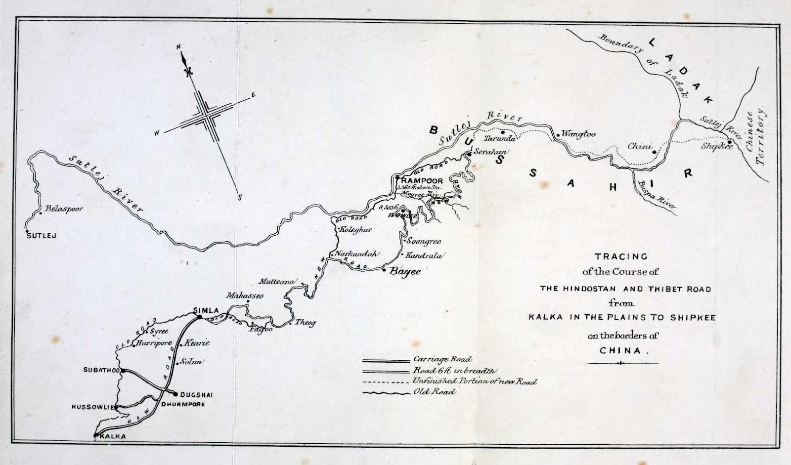
Route 6
via The Hindustan and Tibet Road. Given in ‘Travels in Ladâk, Tartary, and Kashmir’ (1862) by Lieut.- Colonel Torrens 
You could arrive into Srinagar (and still can) via Leh. But to reach Leh you had to take the The Hindustan and Tibet Road road (for sometime the British did think about road linking Delhi and China). Shimla to Shikpi Pass.  Crossing Chandra Bhaga (Chenab) at Koksar on dead inflated buffalo skin.   
-0-

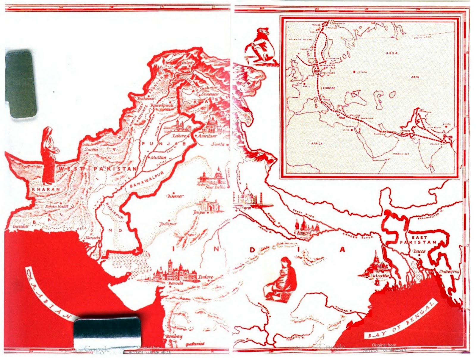
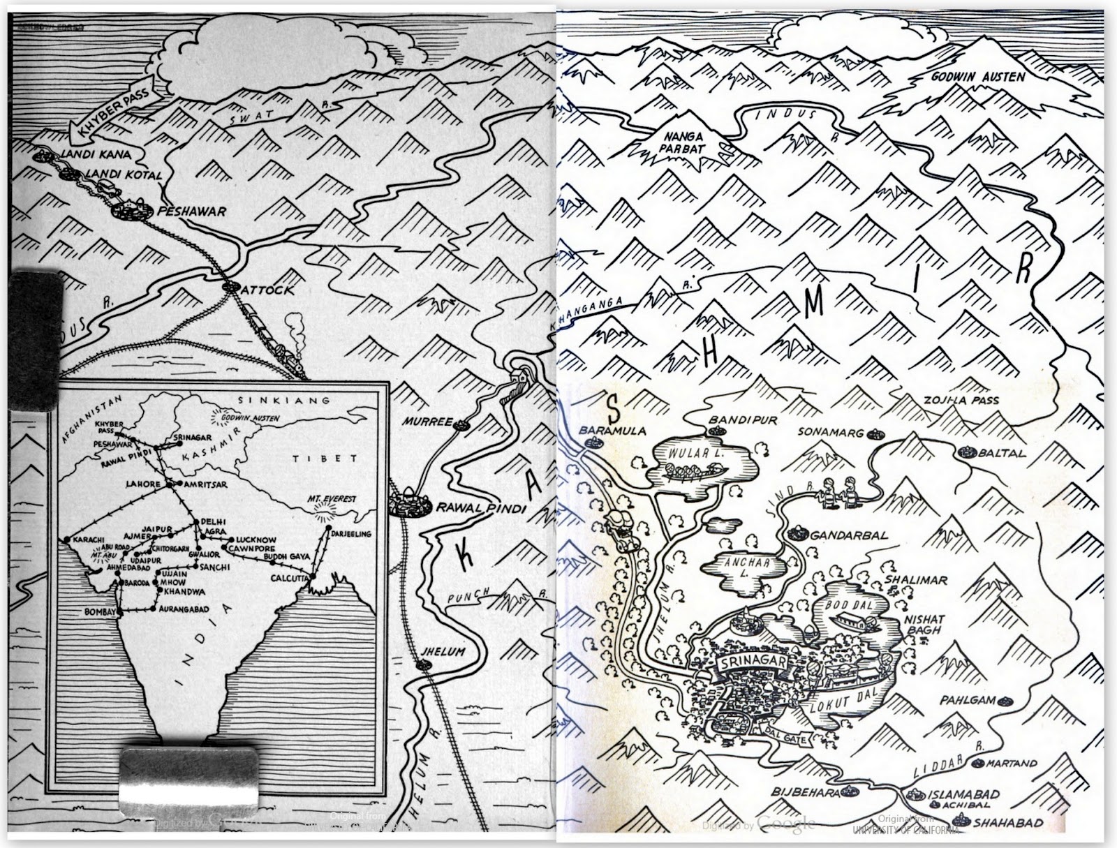
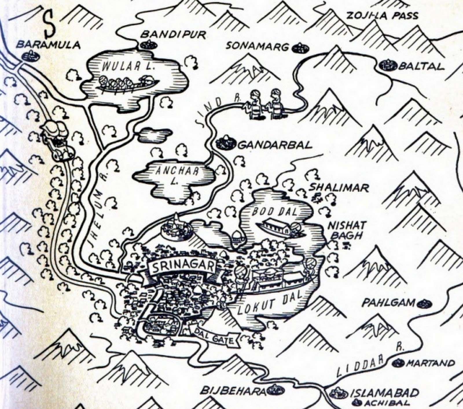
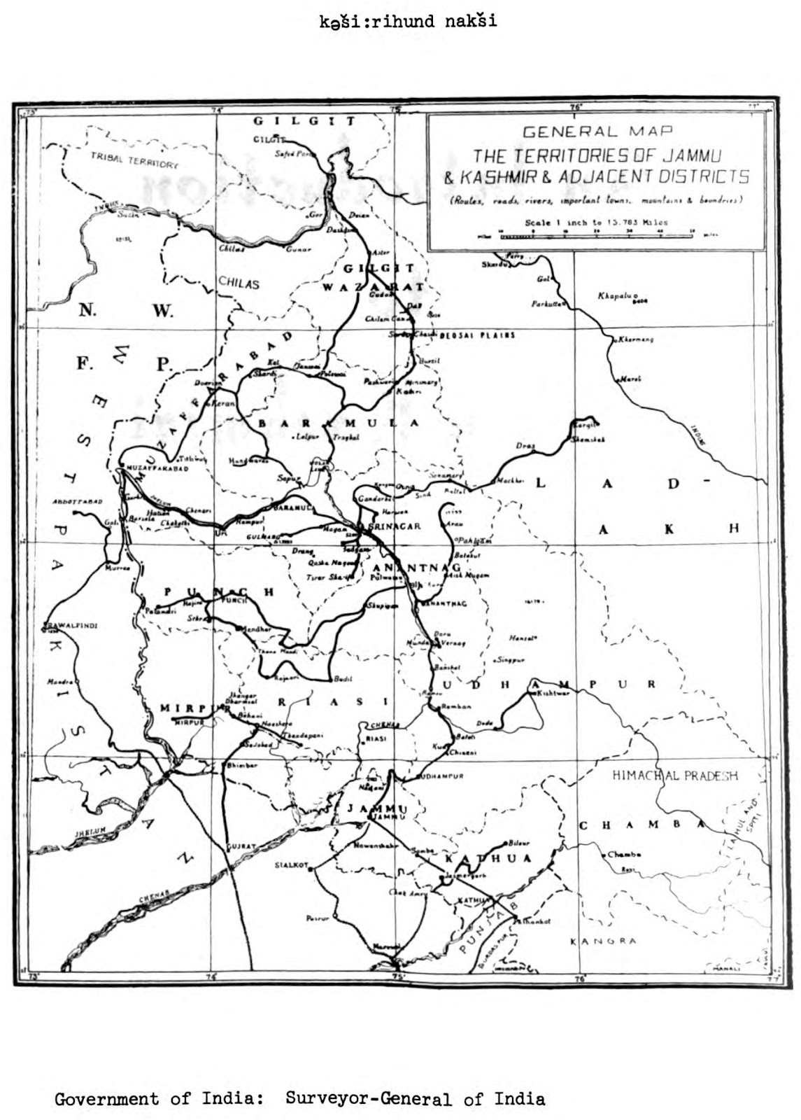
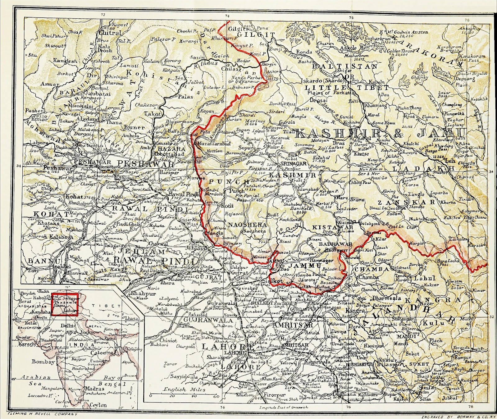
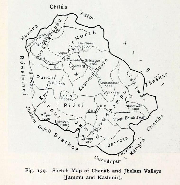
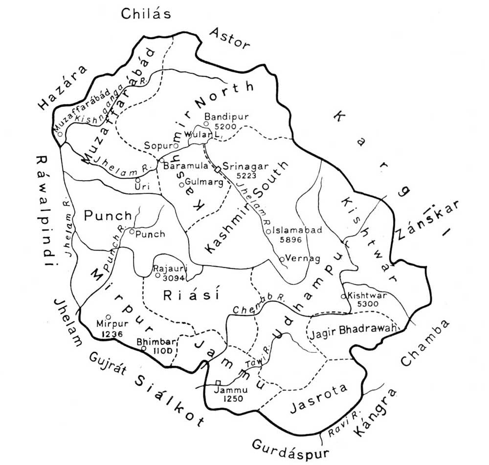
Map of the Kashmir Valley and Jehlum Valley. From ‘The Panjab, North-West Frontier Province, and Kashmir’ (1916) by Sir James McCrone Douie.

Facebook
YouTube
Instagram
RSS