Marc Aurel Stein: Illustrated Rājataraṅgiṇī

Stein’s edition of the Sanskrit text of Rājataraṅgiṇī appeared in 1892 and his two volume annotated translations in 1900. It was his monumental contribution to study of Kashmir, a place which meant much to him.

Over the next few decades, many more people added their own findings to the study of Rājataraṅgiṇī.

In 1920s, in light of new findings, the idea of publishing an updated and corrected new edition of Rājataraṅgiṇī took root in Steins mind. But this was going to be an even more ambitious undertaking. Over the next two decades, Stein planned and worked on his ‘Illustrated Rājataraṅgiṇī’.

In his various letters, he talked about this work:

“The desire here expressed for providing by graphic reproduction an important aid for the student of the Chronicle has been a special inducement to me for undertaking this re-issue of my work. The illustrations of ancient sites, ruined structures, etc., which figure in Kalhana’s narrative, have with a few exceptions been reproduced from photographs I was able to take myself on a tour from October-November 1940. Apart from the pleasure it afforded me of revisiting familiar scenes in surroundings and climatic conditions exceptionally favoured by nature, it offered the welcome opportunity of testing the accuracy of impressions and surveys dating back in many places to close on half a century.”

But then in 1943, Stein died and the fate of this mammoth work of human diligence was unknown and uncertain. It was believed to be unfinished and lost.

Then in  2011, while going through the Stein archives kept in western Manuscripts Collection of Bodleian Library at Oxford, Luther Obrock, came across the almost final draft of ‘Illustrated Rājataraṅgiṇī’. Among other things, the document provided an incomplete handwritten list of photographs to be included in the final book. Obrock was able to trace the photographs in the Library of the Hungarian Academy of Sciences in Budapest and the Bodleian Library at Oxford.

‘Marc Aurel Stein: Illustrated Rājataraṅgiṇī’ was now possible.

In foreword to the work, Obrock writes:

“This book reproduced those photographs with the title mentioned in the dated list. I was able to trace the vast majority of the photographs mentioned, however it must be noted that Stein’s photograph list contained in the Western Manuscripts collection of the Bodleian is incomplete. Stein merely listed some place names as “take” or left the space next to a page number blank. Perhaps another more complete list of the photograph exists, but I have been unable to locate it in either Budapest or Oxford. I have listed the untraced and unspecified photographs or sites in an appendix. I have further decided to include only those photographs Stein positively identified with references in order to give an approximation of his vision of an Illustrated Rājataraṅgiṇī. “

In the book, the photographs occur in the sequence in which the various places are mentioned in Kalhana’s work. Not only places, in most of the photographs you can see how people (unknown, unidentified) were interacting with the places too. Stein’s work had had an impact on Kashmiris too, a lot of these places were getting reclaimed.

Some photographs from the book:

First five are from Library of the Hungarian Academy of Sciences and the last one is from British Academy and the Bodleian Library, The University of Oxford.
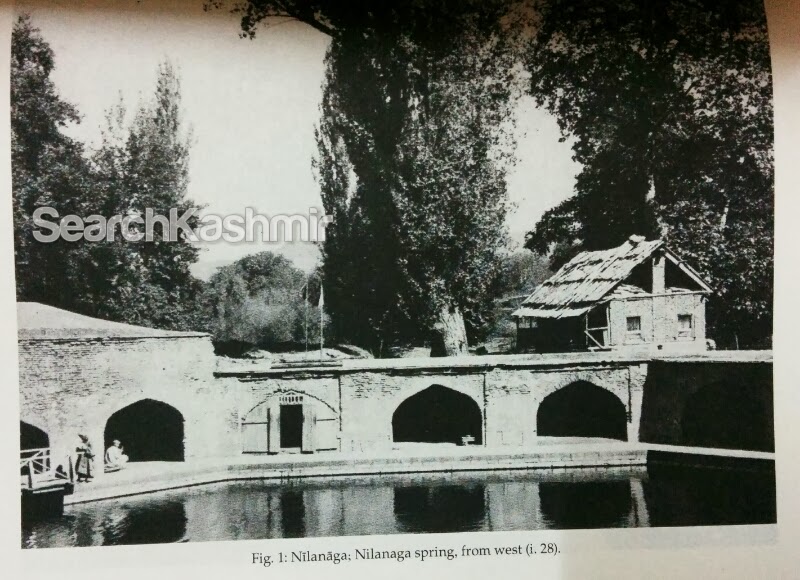
Nilanaga

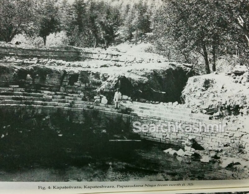
Kapateshvara, Papasudana Naga

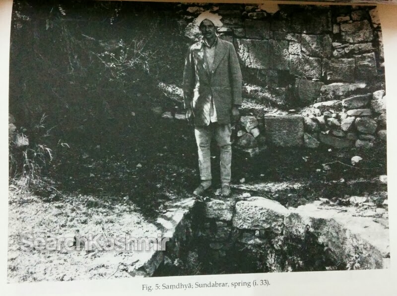
Samdhya, Sundabrar, spring

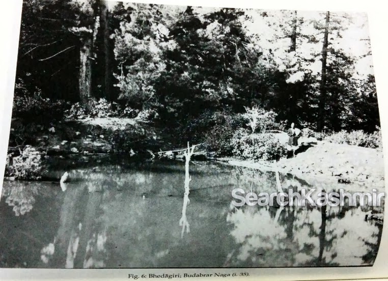
Bhedagiri, Budabrar Naga
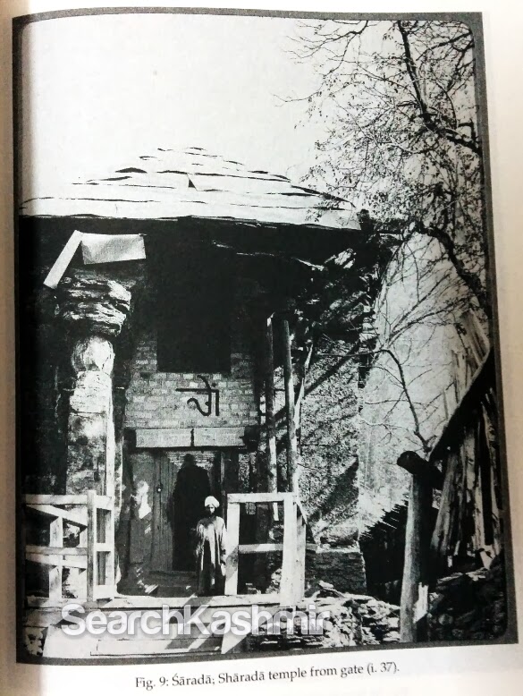
Sarada; Sharada temple 

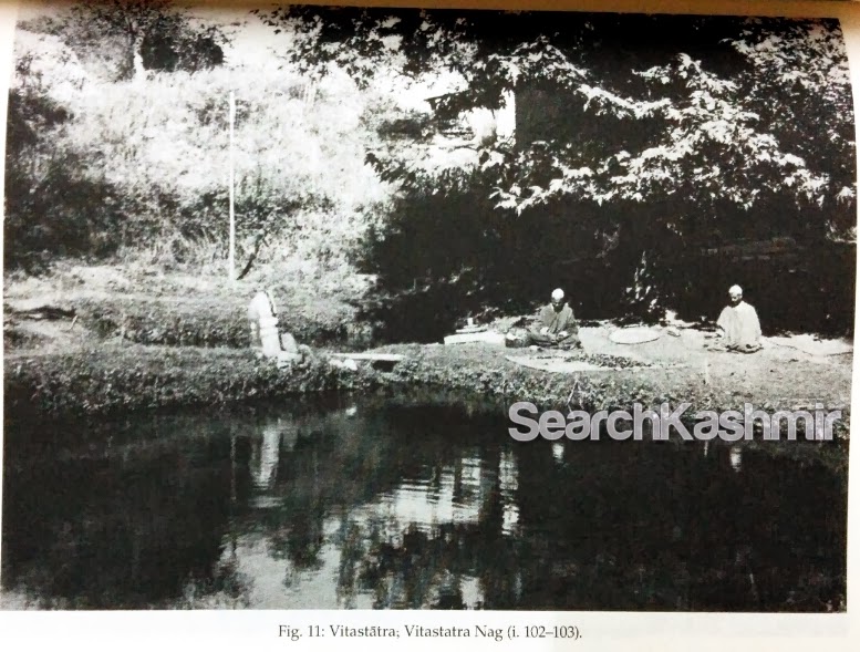
Vitastatra, Vitastatra Nag

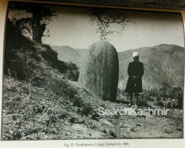
Huskapura, Linga, Ushkur

“To me as a historical student it affords satisfaction to think that my work may help to preserve a record of varied aspects of Kasmir’s intellectual and cultural heritage which, like the country’s climate and other physical features, have markedly distinguished it from the rest of India in the past but are laible to being effaced more and more in future. In a personal way I have more reason to feel gratified that now after the lapse of decades I can still offer these volumes as a token of gratitude for the benefits a kindly Fate has allowed me to derive from the favours with which nature has so richly endowed this alpine land”, Aurel Stein, Cap, Mohand Marg, September 14, 1941.

-0-
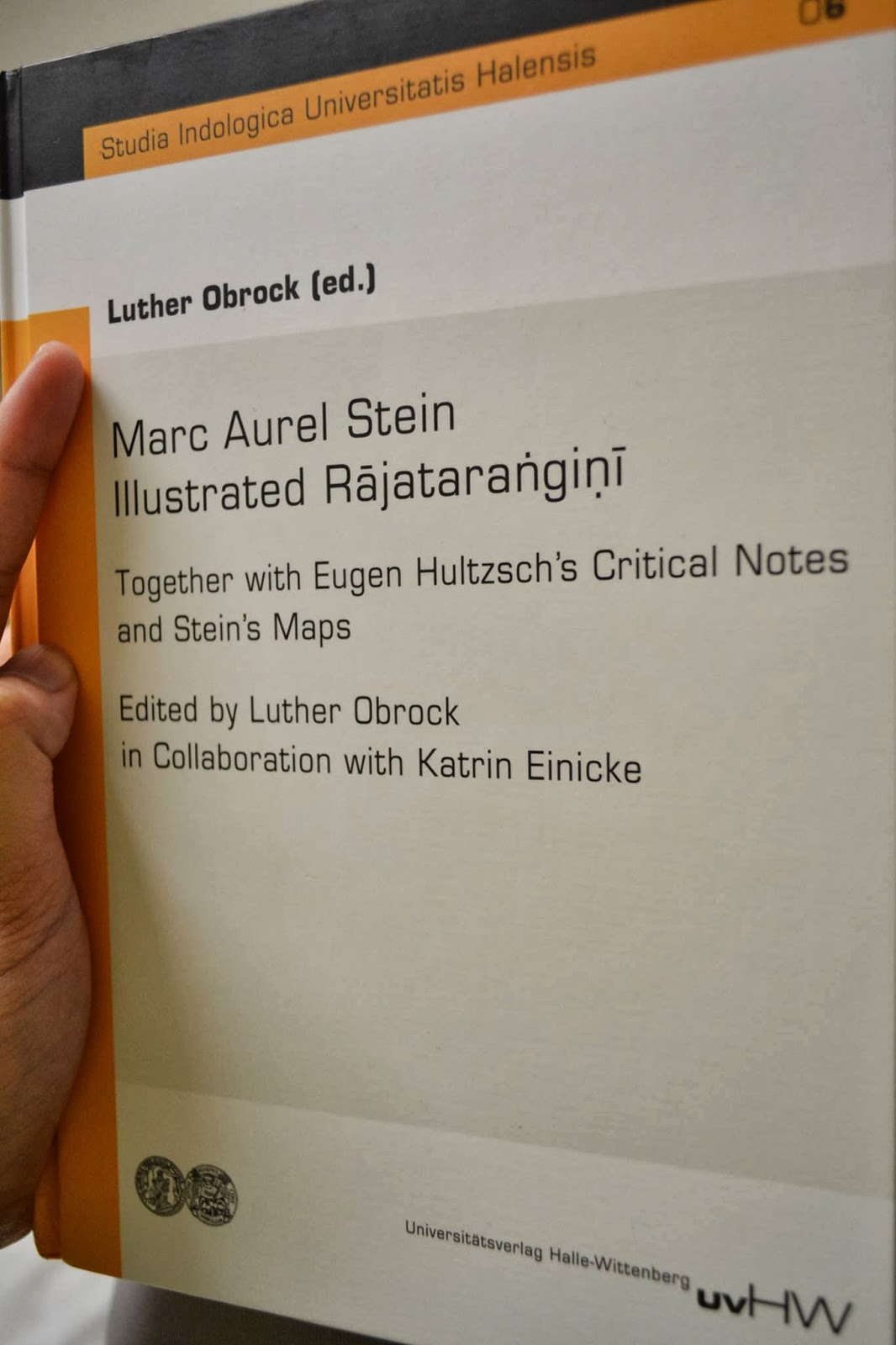
Marc Aurel Stein – Illustrated Rājataraṅgiṇī
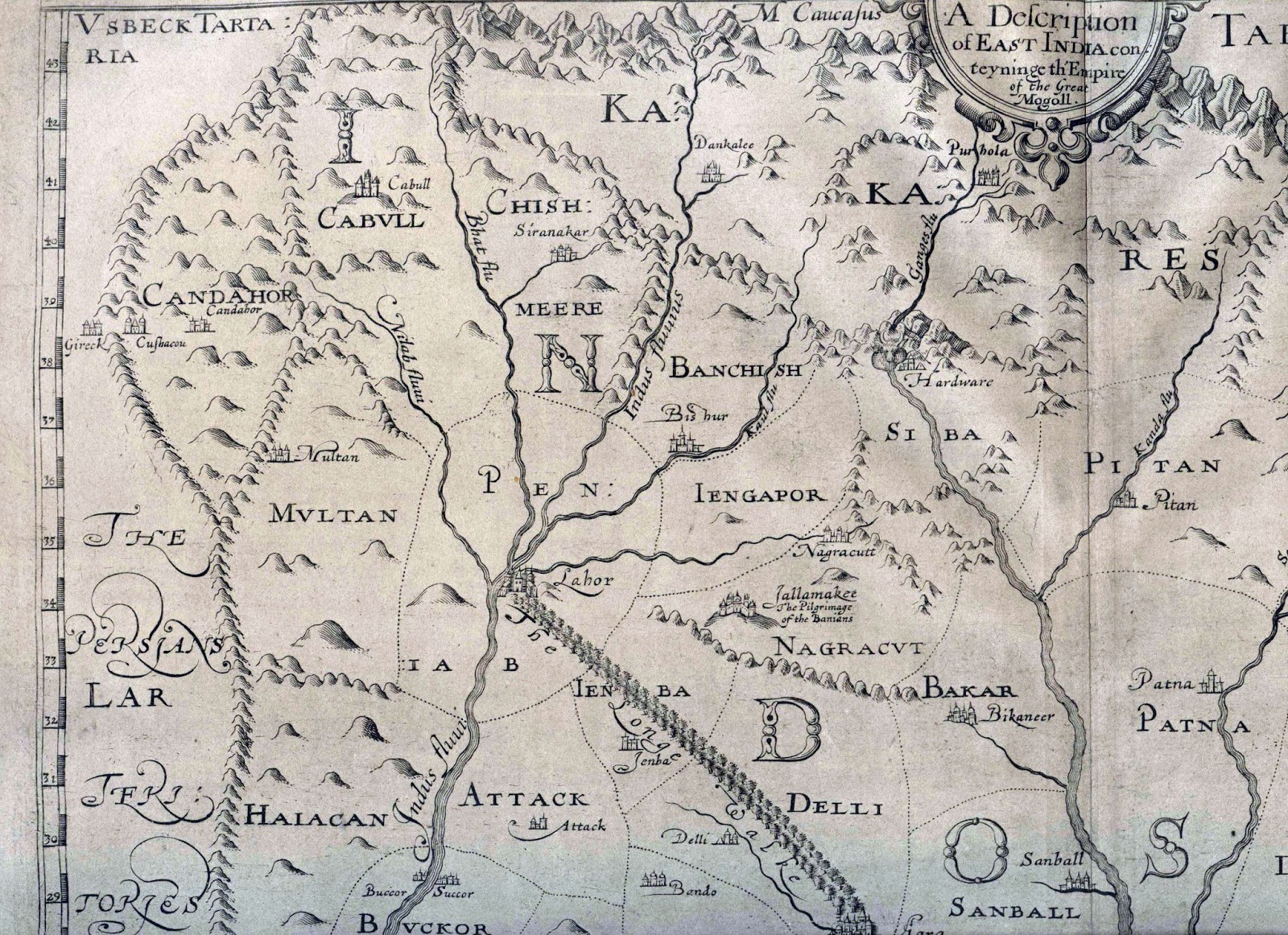
Together with Eugen Hultzsch’s Critical Notes and Stein’s Maps
Edited by Luther Obrock in Collaboration with Katrin Einicke
Studia Indologica Universitatis Halensis, Band 6
2013
248 pages with 82 photographs and 2 folding maps
78,00 €
[Buy here]

A great way to celebrate 150th birthday of the great man.

-0-

Jehlam flows into Bay of Bengala


Goof-up from a time when East India Company had just arrived at Mughal courts:

Kyshmier [Kashmir]. The Cheefe Citty is called Sirinakar [Srinagar]. The Riuer of Bhat [Behat or Jehlam] passeth through it and findeth the Sea by Ganges or, some say, of it self in the North Part of the Bay of Bengala. It bordereth Cabul to the East Southerly. It is all Mountaines.

From the Appendix to ‘The embassy of Sir Thomas Roe to the court of the Great Mogul, 1615-1619, as narrated in his journal and correspondence’ (1899).

A note in the book does point out the obvious error in sending Vitasta eastwards and mentions that William Baffin’s map from 1619 of Mughal empire , based on Sir Thomas Roe’s account did get the direction of the river right.

William Baffin’s Map
[via: columb
ia.edu]

-0-

Two Srinagars

‘The Rope Bridge at Serinagur’ by Thomas Daniell (1800)

“One can only wonder at the fortitude of the early travellers  men such as Huien Tsang, or the painters Thomas and William Daniel. Their determination must have been supreme in order to press them ever forward and eventually reach the Vale, settled as it is high among seemingly impenetrable mountains at the end of a route that was, and still is, full of hazards.”

~ Visiting Kashmir by Allan Stacey (1988).

All that is fine but…

Sometimes a familiar image and a familiar name can cause all find of confusion. A lot of people consider Thomas and William Daniel to be among the first Europeans to reach and paint Kashmir. Painting titled ‘The Rope Bridge at Serinagur’ by Thomas Daniell only confirms it. There are a bunch of books that claim this. All this because the place they visited is Srinagar. But the fact remains, the two never visited Kashmir. Thomas Daniell (1749-1840) and his nephew William Daniell (1769-1837) were in India during 1785 and 1794. In 1789 they visited of the city of Srinagar on the banks Alaknanda river in Garwhal which is named so because . That’s were ‘The Rope Bridge at Serinagur’ comes from.

-0-

Now, coming back to ‘Srinagar’ or rather the two ‘Srinagars’, and continuing with the word games and antonymic folklores… it is believed that the town of Garwhal gets its name after the goddess of Fortune, Sri or Laxmin. Some say the same of the city of Srinagar in Garwhal gets its name from ‘Sri Yantra’, a giant rock which could kill you if you even looked at it. The rock had origins in a tale in which a Goddess kills a demon named Kalasura thanks to the device/rock . The local storytellers say that this rock was turned upside down by Adi Shankaracharya, in the 8th century AD and chucked into Alaknanda. He thus put an end to all the tantric exercises associated with the rock and laid down the plan for the city of Srinagar. Interestingly, there are places in Garwhal were Sri Yantra is worshipped. One of the belief associated with Sri Yantra in Garwhal is that installing a roof over Sri Yantra would bring disaster. [This last bit from ‘Marriage And Customs Of Tribes Of India’ by J. P. Singh Rana (1998)]

The Srinagar in Kashmir still has the Sri Yantra rock at Hari Parbat. The origin of the rock/hill in local folklore has killing of a demon named Jalobhava by a Goddess using a rock, hence laying the foundation of Srinagar. The temple that was reclaimed in Srinagar by Adi Shankaracharya is across this Hill and on top of another Hill that is now renamed after Shankaracharya. The Sri Yantra is roofed at Hari Parbat. Done only in recent times. The only person to protest construction around the rock was an artist named G.R. Santosh.

-0-

Mr. Vigne is responsible for the strange derivation of the name of the Kasmir  capital, Srinagar (Srinagara, or as he spells it, ‘Siri-nagur,’ from ” Surya Nagur, the city of the sun” (p. ii. 137). Judging from the persistence with which the error has been copied by a succession of modern writers on Kasmir, this etymology bids fair to establish itself as a piece of orthodox creed with European visitors to the Valley.

~ Ancient Geography Of Kashmir by M A Stein (1895).

Lost in Space

Moving east, high over the “roof of the world” – the Himalayas – Conrad remembers saying to himself,

“Why must men fight each other instead of enjoying the bounty and beauty of the world?” these are the
snow capped peaks – including K2 (28, 250 feet), world’s second highest mountain – in the extreme
north section of Indian Kashmir on the ill-defined India-China border. China invaded India in 1962
in a dispute over border claims in the area; now India and Pakistan are fighting 150 miles to the south.

Kashmir from Space.
Life. 24 Sept, 1965.

One might look at this and wonder: which one is Dal Lake? Which one is Wular? Is that Jhelum?

Here’s the fun part. None of them are there. Even K2 (mentioned in the article) isn’t there. It isn’t even capturing Kashmir as we know it.  These photographs were taken by Gemini 5 in 1965. Although the accompanying  article doesn’t mention the details. Here are the details (thanks to Google Earth): These photographs were shot while they were over Tibet (‘the roof of the world’) and the region known as Aksai Chin (where the fighting was and where famously “not a blade of a grass grows”). The lakes seen here (from bottom to top) are:
1. Bangongcuo Lake, Tibet
2. Ze Cuo lake at the foot of Zangqung Kangri , Tibet
3. Surigh-yilganing-Kol Lake, Lingzi Thang plains in Aksai-Chin

-0-

Kashmiri Boatmen on Tawi

The ‘biblical’ imagining of Kashmiri Boatmen. 

If on a Jammu bound train you have run into people who ask you if it is going to be cooler once the train reaches Jammu, if they are going to see snow, the mountains, the lakes, the rivers, if your answer has always been a mad laugh, read this blunder of a passage from ‘India, pictorial and descriptive’ (1888) by William Henry Davenport (1828-1891):

“The capital of Kashmir is situated on the Towi, a tributary of the Chenab. It is a place of considerable trade, communication with the riverine district being maintained by water. The Kashmir boatmen are a strong and hardy race, and manage their clumsy craft with much dexterity.”

-0-

Facebook
YouTube
Instagram
RSS